Return History Page
Return Main Page
San Luis Obispo de Tolosa
By: Cortez Cate
January 1, 2005
Updated August, 2020
The following is copied from "California Missions Foundation", PO Box 23035, Santa Barbara, CA 93121, (805)963-1633
History of Mission San Luis Obispo de Tolosa
Located in Central California, Mission San Luis Obispo de Tolosa is named after Saint Louis, Bishop of Toulouse, and was founded fifth in the chain on September 1st, 1772 by Father Junipero Serra. The mission was founded three years after the fathers first discovered La Cañada de Los Osos – the Valley of the Bears – during a failed trip from San Diego in search of Monterey.
As supplies dwindled in 1772 at the already established four missions of California, residents were plagued by shortages of food. Remembering the Valley of the Bears, a hunting expedition was sent in the summer of 1772 to bring back meat. The local Indians were thankful to the soldiers for killing the bears, a feared enemy. Some of the meat was traded with local people in exchange for edible seed, after which time Father Serra decided La Cañada de Los Osos would be an ideal place for the fifth mission. Although the city of San Luis Obispo has not remained a rugged bear country, a statue of a grizzly bear sits as reminder in the mission plaza.
In 1776, four years after its founding, an Indian fired a flaming arrow onto the roof of one of the mission buildings, starting a disastrous fire that severely damaged several buildings. After this incident, the fathers began work on making roof tiles locally, to reduce susceptibility to fire.
As the city modernized, so did the mission. What was once the fathers’ soup kitchen is now this youth center. Mission San Luis Obispo is one of the only missions that never had to relocate; it still stands on its original site.
The mission’s walls, which are 50 to 60 feet high, were built according to Vatican law. This law stated that churches were to be built as tall as the local tree – in this case, the pine. The church, with a long secondary nave forms an L-shaped church, the only one of its kind amongst the California missions.
Father Luis Antonio Martinez, who managed the mission for 34 years, grew a large mission vineyard. He sold some of this wine to the other missions when they couldn’t grow their own, and also exported it as far as England and Russia.
end of cited content
The reason I selected San Luis Obispo de Tolosa is because of the geographical location to my residence. I live in Arroyo Grande, CA about fifteen miles south of San Luis Obispo. Because I have been fondly interested in the California missions over the preceding forty-five years and I have visited many of the missions I have good knowledge of what to expect from the visit. It is the documentation and history of the mission proper that is intriguing and informative. All my assumptions have been formed from prior visits and from the current study of the missions. My personal curiosity of the events that led to the founding of the mission prompted me to expand my research in search of answers to questions I have that the text I am studying did not elaborate on.
Prelude to the California Missions:
The California missions of the Spanish domain began at least two hundred years prior to that first crude shelter being erected in the summer of 1769 at San Diego. Spain dominated the New World in the 15th and 16th centuries. Spain was in a position of dominance and with its seized wealth and trained armies set out to find new sources or wealth and luxury. By 1493 Pope Alexander VI divided the world into two parts, Spain and her principal colonial rival Portugal. Within its half, Spain aggressively pursued a colonial course that brought Mexico, Central America, much of the United States, the Caribbean and half of South America under its control and rule. This was a good bit more territory than what would later to be under the rule of the British Crown.[1]
Spain’s colonies were brought to fruition by methods that were very awkward and complicated. Authority was centralized with the King and his counsel. Then, partly, this authority was delegated to viceroys ((vice-kings) a man who is the governor of a country, province, or colony, ruling as the representative of a sovereign) [2] . Viceroy’s were appointed for one year at a time and were held responsible for civil, religious and military affairs within vast overseas dominions. The planting of the missions in California was under the Viceroy of New Spain (Mexico), located in Mexico City. As one might imagine communication was a prime concern and effective methods were imperative to successful ventures. “Since all transactions were conducted in writing, the governmental machinery operated with glacial slowness”. [3] It took months for a letter to make the round trip from outposts within New Spain itself let alone the time to get word from the King to the governor. A request sent to the King could likely be returned by the New Viceroy….
Because of the communication problems the Spaniards compensated by extremely elaborate written plans of action. Exploring and colonizing ventures were provided with in-depth volumes of rules, instructions and contingency plans. These plans were so elaborate that they dictated the color of the cloth to be given to the Indians. In theory the Viceroy would not need to consult the King. Merely refer to the voluminous set of rules and instructions.
Colonial settlement was developed with closely intertwined cooperation between the clergy and the military. The first stages of the take-over of an alien land were accomplished by use of the sword, the cross or both. The military invasion set the stage in Mexico later to be consolidated with or by the clergy and then ultimately civil authority. In areas where the natives were known to be docile the clergy would open the frontier with merely an escort of military. This latter method being employed in California.
Soon after the expulsion from New Spain of the Jesuits in 1769, Jose de Galvez, Visitor-General, turned the Baja California missions over to military administrators under Captain Gaspar de Portola and then to the Franciscans under Father Junipero Serra. Galvez was the most effective visitor-general in the history of New Spain. The vista was a distinctively Spanish Administrative technique for investigations and reorganizations, and a visitador-general was a special deputy of the King, with extraordinary powers overlapping and sometimes transcending those of the Viceroy.[4]
The urgency to now colonize Alta California, some one-hundred sixty-seven years after Sebastian Vizcaino had discovered and mapped the coastline, was prompted by fear that the Russians had eyes set on the territory and may be planning to seize it. Plans were immediately dusted off and twin expeditions by land and sea were to be sent from a base in Baja California to colonize the port of Monterey, with the port of San Diego selected as an intermediate stopping point. Leadership of the project was assigned to Portola who had recently been appointed governor of Baja California. Since there was little to govern in Baja, Portola was delighted to lead the party. Under Portola, Fr. Serra was relieved of his presidency of the Baja missions to take charge of this more important work. The master plan and rules had long been in place but as with most undertakings of this type the leader had authority to make changes according to their views. These appointments and the subsequent actions of these two capable men marked the beginning of the development of California.
San Luis Obispo de Tolosa Founded September 1, 1772:
When Portola headed for Monterey around September 7 - 8, 1769, he and his party traveled through the future San Luis Obispo area on his way to rediscover (remember that initially on his first visit he did not recognize Monterey because of Vizscaino’s exaggerated description of) the Bay of Monterey. The expedition’s secretary, Padre Juan Crespi, O.F.M., listed the name given to this area by the soldiers as llano de los Osos, or the level of the bears (Bear Plain) simply because of the great number of bears sighted and the evidence or their presence. Various translations of the Crespi Diary have called this area La Canada de Los Osos (The Canyon of the Bears) which has been further mistranslated as the Valley of the Bears. At any rate it is known today as Los Osos and it is commonly called the Valley of the Bears. The valley can actually be credited with the salvation of the entire mission expedition because it is unknown what would have happened had the expeditions of the future not remembered this valley for its valuable food source.
MISSION IN THE VALLEY OF THE BEARS: A DOCUMENTARY HISTORY OF SAN LUIS OBISPO DE TOLOSA / CALIFORNIA A SORROWFUL MISSION: A DOCUMENTARY HISTORY OF NUESTRA SENORA DE LA SOLEDAD. The Journal of San Diego History SAN DIEGO HISTORICAL SOCIETY QUARTERLY Winter 1988, Volume 34, Number 1 Thomas L. Scharf, Editor BOOK NOTES Raymond Starr, Book Review Editor Mission in the Valley of the Bears: A Documentary History of San Luis Obispo de Tolosa. Edited by Francis J. Weber. Hong Kong: Libra Press Limited, 1985. 240 Pages. $18.00 California a Sorrowful Mission: A Documentary History of Nuestra Senora de la Soledad. Edited by Francis J. Weber. Hong Kong: Libra Press Limited, 1985. 159 Pages. $18.00 These two volumes continue Francis J. Weber’s “California Mission Series” which will include a collection of sources on each of the twenty one Franciscan missions in California. San Luis was established in 1772 in the Valley of the Bears; the modern community of San Luis Obispo grew up around it. The Soledad mission was the thirteenth established (in 1791) and was located at the base of the hills around the Salinas Valley. It suffered from drought, sickness and other problems and remained small. After Secularization it rather literally melted into ruin. Following the pattern for the series, each volume contains a variety of items ranging from excerpts from official records to letters, newspaper and magazine articles and other materials. The volumes are primarily for the layman inasmuch as they do not contain the usual scholarly apparatus of full citations, etc.
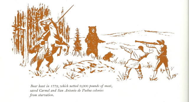
In 1770, Fr. Serra founded the second mission, San Carlos Borremeo, in Monterey which was moved to Carmel the following year. As supplies dwindled in 1772, at the then four missions, the people faced starvation. Remembering the Valley of the Bears, a hunting expedition was sent to bring back food in the summer of 1772. Over 25 mule loads of dried bear meat and seed was sent north to relieve the missionaries, soldiers, and neophytes (baptized Natives). The Natives were impressed at the ease by which the Spaniards could take down the huge grizzles with their weapons. Some of the meat was traded with the local people in exchange for edible seed. It was after this that Fr. Serra decided that La Canada de Los Osos would be an ideal place for the fifth mission. The area had abundant supplies of food and water, the climate was also very mild, and the local Chumash were very friendly. With soldiers, muleteers, and pack animals carrying mission supplies, Fr. Serra set out on a journey to reach the Valley of the Bears. On September 1, 1772, Fr. Serra celebrated the first Mass with a cross erected near San Luis Creek. The very next day, he departed for San Diego leaving Fr. Jose Cavaller, O.F.M., with the difficult task of building the mission. Fr. Cavaller, five solders and two neophytes began building what is today called Mission San Luis, Obispo de Tolosa.
Building San Luis Obispo
Father Cavaller was able to enlist the aid of the local Chumash Natives. Palisades were set up as temporary buildings, which were made simply from poles and tree boughs. These structures were quite susceptible to fire and on a November night in 1776 the first of several fires was spotted by a watchman. The fire spread quickly as the watchman roused the residents to fight the blaze. Everything was consumed except the church and granary.
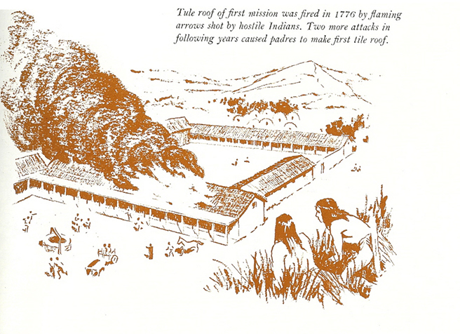
This fire and the ones that followed prompted the father’s memory of the tile roofs widely used back in the homeland of Spain. Soon they realized that this (tile roofs) would be of great value in face of the continued opposition that it appeared they were to face…….The experimental manufacture of curved tiles began circa 1790. Their first tiles (of which a few specimens still remain) were about 22 inches long and tapered from 12 to 20 inches across. Mission tile is today the best know name in tile roofing products.
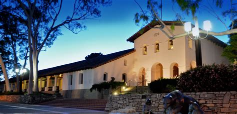
Because of fires in the first few years, adobe and tile structures would now become the preferred method of construction. The Church and Priest's residence, the convent wing, were built by 1794. Many other structures made up the Mission in the early days: storerooms, residences for single women, soldiers barracks, and mills. The mission also had land for farming and raising livestock. The whole community of priests, Natives and soldiers needed to produce goods for their own livelihood. These pictures show the mission as it was originally constructed. This first picture is the Southerly side of the Mission San Luis Obispo de Tolosa; this being the side that is alongside the creek that is just out of view but only about 150 feet from the mission walls. This is the court yard of the mission and is a beautiful park setting today with its future secure that it will never be destroyed or significantly changed
Later (last page) there is another view of this same area but as it is today. I think it is important to note the significance of the mission to the development of the area and also the feeling can almost emulate from the people in this picture that this is their place and it is the center of their lives. When one gives serious thought to the overwhelming influence that the missions had and how that exuberated to the people who chose or were drafted (as is the case of the neophyte) to live there; we then must be compelled to give credit and pay homage (with some reservation) to these courageous Franciscans that made this possible.
Next is an old picture of the church from circa 1880. This was a time when earthquakes had taken their toll and a remodeling was due or under way. Note the boarded exterior and the absence of the roof tiles (removed because of weight considerations during the remedial period) but the presence of the New England steeple. Also note the wing to the right of the main hall of the church. Actually that wing has been expanded a bit and now the seating is nearly the same in either wing. I will show the first remodeling following this picture from around 1930 when the boards were removed and the adobe restored to the original texture.
[8].jpg)
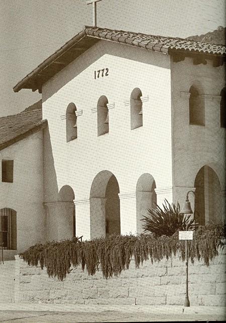
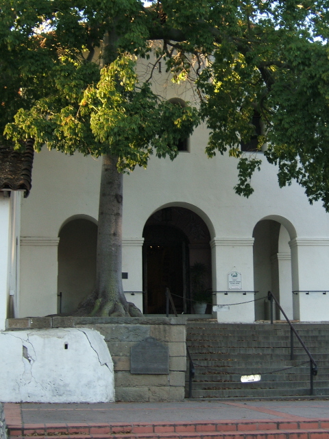
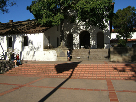
Note the date 1772. The next picture will be circa 1930. Today the building is exactly as it was here but you will notice a good bit of tree growth and the leaves and limbs partially obscure the date over the church entrance. Actually I am uncertain what would be properly described the entrance here, there is one from the court yard and three more on the other wing (remember the one on the right? it is back there) but I don’t have a good shot of it. But you can see it just past the corner, that wing is about 150 feet of so beyond the corner of the church. We did not get the date, 1772, visible in this photo. It is almost visible in the photo on page 8 line 19 but obscured by the tree.. I attended mass here today, Sunday January 30, 2005 and there were at least 200 people in attendance. Fortunately there were three baptisms during this mass, two were about 8 year old twin brothers and the third was a baby boy about 18 months old. Here am I standing just outside the entrance following the 9:00 a.m. mass.
Judy going up the steps to Church in 2005. The Church/Mission sits above the Creek to the North. Father Serra chose this site for the Mission because of it's proximity to the Creek as the Mission sits above the creek and parallel to the Northerly direction.
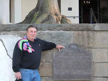
Cort (the Author:) by small plaque Janurary 31, 2005: this is just below the church and the picture above (or to the left) shows the steps leading up to the Chapel and I standing near the door to the Chapel.
The mission proper covers a full block and has always been the focal point of San Luis Obispo fully functional and very active. I remain profoundly in awe of this extraordinarily beautiful creation.
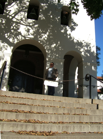
This is a little better picture just to show the date on the church. Look behind the limbs. You need good eyes.
Notice how the tree has grown up around the entrance. The next photo, below, is me near the statue of Father Serra; about 30 – 40 feet to the right of the steps above and right. Having satisfied the two picture requirement let me at least show a couple of more shots that depict the great beauty of this mission and the surrounding town.
These photos of the creek (Fr. Serra chose the site of the mission because of the creek) that the rest of the town has built over. That’s right the creek runs under the town streets and buildings for about 7 or 8 blocks and being a popular field trip for Cal Poly students. This is looking in an Easterly direction from about 100 feet in front of the church entrance.
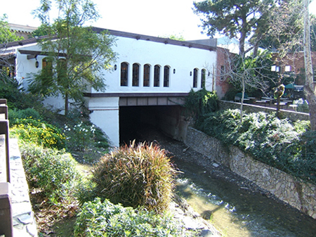
The Creek is tunneled under the City about 8-10 blocks and many are never aware it is running under them. This view is towards the East up Cuesta Mountain where the creek heads.
Judy going up the steps to Church in 2005. The Church/Mission sits above the Creek to the North. Father Serra chose this site for the Mission because of it's proximity to the Creek as the Mission sits above the creek and parallel to the Northerly direction.
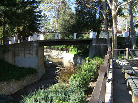
The Creek flowing on Westerly to the Ocean at Avila Beach.
The next photo is of the creek running the other direction, Westerly. The creek does run year around and is fed by springs from the mountains east of the city. The city has done a beautiful job of protecting and utilizing the natural resources and beauty that they have been endowed with. For the most part the city is good at maintaining the mission atmosphere.
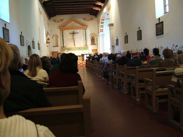
The next photo is inside the church from the entrance that I have shown above (3rd and 4th picture) during mass. Five or six people can sit in each pew and there about 40 rows.
One can get a concept of how large the room is. It is hard to see but the large ceiling beams are about 10 x 24 hewed beams on about 4 foot centers. The pulpit is laid out in a diagonal so that both wings are faced. You can see the beautiful arch on the other wing.
By the way, this is the only one of the twenty one missions that had a church layout in this ‘L’ shape with the two wings.
Anyone who would like pictures, that I processed can copy from my website, http://cortezcate.com but there are tons of pictures available now that were harder to find when I first wrote this report
Four pictures back I am standing under a statue of Father Serra. Physically he was a very small man, barely 5’2” tall but, emotionally, professionally, vocationally and as a visionary this man was truly a giant among men. I have developed doubts about the motives and true spirituality of Father Serra as well as the Franciscan order in general. These are personal observations and not supported by documentation at this time.
Commerce, Productivity and Population:
The Spaniards kept meticulous records of mission activities. Each mission was required to submit an annual report summarizing its spiritual and material condition and status to the Father-President. It was truly remarkable of the progress that the missions accomplished. For me it is an eye opener to read other reports of the missions because I feel the history books should give a bit more credit and explanation of the remarkable progress that the missions actually achieved. I was under the impression from out text that they were borderline failures. A good explanation is what I need of why there was so much friction between the political and clergy arms of the new settlements and if that were common or was it isolated to California? I am beginning to believe that it was the leadership of Father Serra that was so far in advance of anyone who had come before him and this likely created a jealousy in the political arm of government causing the politicians to attempt to suppress the mission activity. This is however pure speculation (as well redundant) on my part at this time and while I fully intend to investigate further and attempt to learn what actually happened I do not take a firm stand either way right now.
Spiritual (Population):
The spiritual records as of December 31, 1832 are both impressive and a little bit puzzling. San Luis Obispo reports 2,644 baptisms, 763 marriages, 2,268 deaths and 231 neophytes. These records are cumulative. San Diego reports 6,522 baptisms, 1,794 marriages, 4,322 deaths and 1,455 neophytes. San Luis Rey the 18th mission founded in 1797 reports 5,399 baptisms, 1,335 marriages, 2,718 deaths and a whopping 2,788 neophytes. It is obvious they were doing something right (hopefully) at San Luis Rey. Regrettably I have run short on documentation concerning population. The mission had some information on exhibit but I must have neglected to properly record it and have not been able at this time to recover that information.
Material(s):
At San Luis Obispo (remember, the totals as to the Spiritual Records are cumulative but the material lists are ‘as of’) as of 1832 there are 2,500 head of cattle, 5,422 head of sheep, 700 horses, 200 mules, for a total of 8,822 and additionally there is 97,405 Fns. Wheat, 31,346 Fns. Other.[9] Compare to San Luis Rey with 27,500 head of cattle, 28,100 head of sheep, 1,300 goats, 300 hogs, 1,950 horses, 180 mules, for a total of 57,330 head of livestock. Additionally they have 26,452 Fns. Wheat and 66,204 Fns. Other.[10]
San Luis Obispo’s rank is rather low in the material aspects with only 5 missions being lower in totals. San Luis Rey on the other hand has twice as much as its nearest competition which is San Gabriel with 26, 342 head and San Jose a close third with 24,180.[11]
I have not been successful, as of this writing, in locating accurate records pertaining to the number of persons actually at the mission at a given time. In the Spiritual lists above I noted the large number of neophytes that San Luis Rey reported but this is a cumulative record I believe. I want to learn what the ongoing totals of population were at given times and will seek that information during this course. If anyone could lead me in a direction that would reveal this information my email is cecate@pacbell.net .
These numbers do not tell the whole story but gives an idea of how viable the missions were. They had actually reached their peak around 1832 just two years before secularization in 1834. One wonders if they were just coming to fruition or if this was just an anomaly of the history. There seems to be little doubt that the natives were ever much more than forced laborers. Certainly the missions and the government failed to grant the natives the education necessary for their blending with this new society. All that can be learned in the missions, rancheros and presidios blends perfectly with the study of the history of this great state. It is sad that such atrocities were committed both before and after this great state joined the United States of America. It seems that all governments I have studied practice or permit extreme racism at certain times in their development. There are still wrongs that our government, the United States of America, needs to set right or as near right as is humanly possible at this point in time.
The Missions of California is a story for all times and has forever left an indelible impression on me. I am inspired to continue to study and learn more of this great institution and this great State.

(1) Above the fountain depicts the Los Osos connection; Fr. Serra, cross and church in the background. (2) SW corner (this is same area as the first, page 6, line 10, of the old photos above) today. (3) Me at the plaque near church entrance. (4) Looking west, 100 feet from church entrance.
[1] The California Missions, A Sunset Book; Lane Book Company, Menlo Park, California
[2] The American Heritage® Dictionary of the English Language, Fourth Edition Copyright © 2004 by Houghton Mifflin Company. Published by Houghton Mifflin Company. All rights reserved.
[3] The California Missions, page 11, paragraph 3:
[4] California: An Interpretative History, Eight Edition page 31
[5] From The California Missions page 114.
[6] From The California Missions, page 115
[7] From The California Missions, page 120
[8] Both pictures are from The California Missions pages; 120 and 112
[9] Fns. - Fanegas, a Spanish measure equal to 100 pounds.
[10] Other includes barley, corn, beans, peas, lentils, garbanzos.
[11] Information garnered from notes taken from exhibits and information found at Mission San Luis Obispo.
Take a Virtual Tour of Mission San Luis Obispo de Tolosa